
Friday, August 5, 2011
The End
Uranium Tailings
 Well the mosquitoes made it a little hard to sleep but I have been through worse things in my life. We tried to hike to the junction of the Green River and the Colorado River but the trail was closed. So we just did a quarter mile hike which was fun. We then headed back to Moab and went to an old uranium mine less than a mile from our campsite. Which had all of its tailings less then 30 feet away from the Colorado River. This is the same uranium that destroyed Japan and the same uranium that turned Chernobyl into a barren waste land. I know its not that serious but I think it is should be a little more protected than a huge pile next to the river. The uranium mine was discovered in 1952 and was in production until 1984. the crazy thing is that all of their radioactive slurry was put in an pond, that was not lined with anything, and a 90 foot high radioactive tailing pile right next to the river. It is believed to be leaching into river, which has lead to high concentrations of ammonia and has caused a negative impact on the fish in the area.
In 2005 the Department of Energy announced that it was going to move 11.9 million tons of the tailings to a lined hole 30 miles away onto public land in Crescent Junction, Utah. At first the relocation was expected cost 300 million dollars, now estimates are over 720 million dollars (Salt Lake Tribune). By March of 2010 1 million tons have already been shipped (DoE).
Citations:
"First Million Tons of Moab Tailings Shipped to Crescent Junction for Disposal." U.S Deparment of Energy, 3 Mar. 2010. Web.
http://www.em.doe.gov/pdfs/1MTons_newsrel.pdf
"Let's Move It: Atlas Tailings Should Be Transported Quickly." The Salt Lake Tribune, 8 Aug. 2008. Web.
http://www.sltrib.com/ci_10144500
Picture Citations:
"Moab Tailings." Tom Till. Associated Press. Web. 2008.
http://www.deseretnews.com/photos/midres/5837965.jpg
Road Trip
 Today was a total driving day. We left Reno at 8:00 am and headed to Ely where the groupwould be camping. Along the way were got a nice tour of nothing because we drove down Highway 50, The Loneliest Road in America, but we did eat lunch in Eureka, apparently the friendliest town in America. We got to Ely and stayed for less than 20 minutes and then Tait, Kyle and myself headed to Flagstaff to pick up the Suburban which was getting a new transmission.
I am kind of jealous that I did not get to stay at the campsite and explore because it was beautiful. It was a couple miles down a dirt road tucked into this small canyon. I bet a only a few people have ever been witnessed its glory. The only problem was that the little stream that ran through the campsite had 300% snow pack so it was flooded with pure ice water. So I guess it was good we left. We got
to Flagstaff at 2:00 am and went to sleep after a solid 18 hours of driving.

Finally in the morning were were reunited with Command Center 1, our beloved Chevrolet Suburban. It may have not been as comfortable as the rental but it is what I have called home for the past 3 summers, so I was happy to have it back.

We then drove to Moab where we met up with the rest of the group at the same exact campsite where the geology club almost died 4 years ago. But it seemed like the tamaris was back to shield us from the wind so we should be good. We then headed to Arches National Park, just in time to see the sun setting on Delicate Arch and it was jaw dropping. This is my third time being at Delicate but the first time to witness the sunset. We headed back before it go dark, ate dinner, and stared out at the stars. I thought the stars were amazing before, tonight they were mind blowing. It was a good day.
Picture Citations:
"Eureka." Anthony Sarnoski. 2011.
"Dirt Road Campsite." Anthony Sarnoski. 2011.
"Command Center 1." Anthony Sarnoski. 2011.
"Delicate Arch." Anthony Sarnoski. 2011.
Reno
Reno was awesome. The hotel had awesome breakfast, I ate it twice. Brought some back to my room and I do not think I left the hotel room all day. It was nice to finally have a day to do absolutely nothing. It would have been nice to see Lake Tahoe. I heard it was beautiful but a lot of people did not want to go so we just hung out.
Hetch Hetchy Reservoir
 Today we got up early to get a tour of Moccasin Power Plant, which uses water from the Hetch Hetchy Reservoir. Our tour guide brought up the fact that hydropower is one of the most efficient forms of energy production. It is available 24 hours a day whereas solar is only efficient during sunny days and wind is only efficient at night when energy is not needed. The only problem they have is that at night they make too much energy and have to pay people to use it. I think that it would make more sense to build a pump storage facility and use the energy they would normally have to pay people to take and pump water with it and they produce even more power during peak hours. The reason that that has not happened is energy is not the reason the reservoir is there, it can conveniently produce power but the reservoir is there to manage water. The main purpose it to ensure that San Francisco receives between 220 and 290 million gallons of water a day. That number is simply outrageous and San Francisco still needs more water than that. The water is transported more than 140 miles from an elevation of of 900 feet to 325 feet all by gravity. I wonder if adding small turbine inside the pipes to create extra energy would be possible.
The main controversy with Hetch Hetchy is that it is in Yosemite National Park. The park is suppose to protect and preserve but it has an unnatural reservoir in it. I would rather the reservoir not be there to make Yosemite as pristine as it could possibly be, but I understand that it is not possible to remove it. The ecosystem is adapting to the reservoir and removing it would leave an uglier scar then what the reservoir is now. It is crazy to think about how beautiful Yosemite Valley is and Hetch Hetchy is the exact thing filled in with water. So it is kind of sad to think about what beautiful landforms are buried under all of that water.
There is a positive though, since the headwaters of Hetch Hetchy are in the National Park they are pristine. That means that they are very clean and have a low sediment load. So they are able to have a filtration avoidance which is good because the water will be pure and cheap but is a little scary. That means from the spring to your tap the water is only chlorinated. There are a lot of harmful things that are not killed by chlorine but would be removed by a filtration system. So far it has not been a problem but it would not take a terrorist very much to poison the entire San Francisco water supply and by the time it is caught 2.5 million people could be dead.
Picture Citations:
"O'Shaughnessy Dam." Anthony Sarnoski. 2011.
"Hetch Hetchy Reservoir." Anthony Sarnoski. 2011.
Yosemite
 This was the second time I have been at Yosemite and it was just as beautiful as the last time I went there. We did the Vernal Falls hike again and this time it was absolutely breath taking. This year there was a 300% snow pack so the volume of water flowing over the falls was three times as much as normal. The spray from the water fall was more like a monsoon than a mist. The valley is absolutely beautiful as well. The only problem is there is a lot of traffic. I wish that Yosemite would try to be more like Zion. In Zion cars are only allowed to travel so far and then you can only take the bus to most stops. This means there is no traffic and a lot less pollution. This would be a smart thing for all National Parks to do and it would be very easy and cheap to implement. Hopefully one day that will happen.
Picture Citation:
"Vernal Falls." Anthony Sarnoski. 2011.
Hilmar Cheese, Irrigation Canal + Methane Digester
 The tour of the Hilmar Cheese Factory was less exciting then I expected it to be. It was again a tour more deemed for an elementary school group them college kids. It was pretty much the exact talk that Mike gave us the night before. It was cool to be in the countries largest cheese factory but thats about as good as it got. They did not even make very cool cheeses. Just normal cheese like cheddar, colby and pepper jack. It was still crazy to hear that they produce over 1.5 million pounds of cheese a day. I was confused at why I have never heard of Hilmar, and that was because they do not sell their cheese in supermarkets. They sell itin bulk, only putting their name on it for the factories gift store. I do not know why but I never connected whey protein powder as the same thing as whey from milk. But they say that they do not only make cheese here they also use to the whey to make supplements and they use the extra water to clean the plant and to irrigate the property, which I thought was pretty smart. We then stopped at the gift store sampled some cheese and head out.
The next stop was a quick stop to talk about the irrigation canals that they have been using for hundreds of years. A lot of the land in the midwest is irrigated using these irrigation canals. They are cement line canals that flow along the property and have pumps which the farmers can use to irrigate their property. The problem is that they are highly inefficient, they are cement lined so that no warm can seep back into the soil but they are not covered so the blistered 120 degree temperatures out there evaporate off a lot of the water. Also with any open body of water animals can fall in an die or chemicals can be spilled into it and contaminate the entire water supply. The main problem with this canals is more with water management. Each farmer is allocated a certain amount of water. If they use it they are fine, but if they use less water, in the future they will be allocated less. The problem with that is in dry years where less water is available those people that did not waste water will have they water supply limited and it may not be enough water to support their crops but the people that have been wasting their water have plenty of water to support themselves. So a large amount of the water is wasted each year because farmer use flood irrigation instead of practicing efficient irrigation techniques. This is frustrating because a lot of people complain about water shortages and the farmers are wasting countless amounts of water each year.

Last stop of the day was to a dairy farm with a methane digester on the property. This was very interesting to see but had a terrible stench. It was cool to see so many different ways to make electricity. This facility produces about 500 kilowatts of power, which is enough to power his whole farm and sells some back to the power company, but is limited. Right now he uses animal manure and any organic waste from the farm, he is not allowed to use waste from other farms yet because of regulations but he says that with new parts and the extra waste he could easily produce 2 megawatts of power. That would make the facility cost effective because right now it still costs him money to run and has been operational for about 2 years. With the amount of electricity he is making his farm his is regulated as a utility company.
The digester works but taking the fresh cow manure and keeping it heated to between 100 and 102 degrees to make it the same temperature as the inside of the cow. This temperature keeps the bacteria inside under natural conditions so that they continue to produce methane. The methane is then trapped and then burned in a generator, creating electricity.
Picture Citations:
"Hilmar Cheese." Hilmar Cheese Company. Our products. Web. 2011.
http://www.hilmarcheese.com/uploadedImages/Content/Section_Content_Units/Products/products1.jpg
"Irrigation Canal." James S. Alber. Emporia State University. Web. 2009.
http://academic.emporia.edu/aberjame/wetland/canal/sand1.jpg
"Methane Digester." The Encyclopedia of Alternative Energy and Sustainable Living. Anaerobic digester. Web. 2011.
http://www.daviddarling.info/images/anaerobic_digester_diagram.jpg
Altamont Pass Wind Farm + Mikes Farm
 Driving by the the Altamont Pass Wind Farm was definitely a sight to see. It is the largest wind farm in the United States at almost 10 miles across. It was also the first wind farm set up by President Cater after the energy crisis in the 1970's. There are 4390 wind turbines on the property, but that sounds a lot better on paper then in real life. The majority of the wind turbine there are very small and inefficient, so those 4390 turbines are only producing a maximum of 576 megawatts but they only run at 20% efficiency so that is about 115 megawatts. Which for 4390 wind turbines is pretty bad. But it is clean wind power so it is 115 less megawatts producing by burning fossil fuels.
 Of course with all clean energy there are still problems. The main problem is that Altamont Pass is the main migration route for raptors. So at this farm over 50 golden eagles are killed each year. If the wind farm is transformed into a newer high-tech wind farm this would solve both the inefficiency problem and the raptor problem because newer larger wind turbines create more power and kill less birds.

After visiting the wind farm we drove to Tait's friends dairy farm. This was a very cool experience because I have never been on a dairy farm. Mike and his family were extremely hospitable and his two children were adorable and very playful. He made us feel right at home so we had a little cook out and set up camp in his front yard, 10 feet a way from thousands of dairy cows. Later that night he took us on a tour of the farm which he said operates 22 hours a day. So we go to see it in action. First he showed us all of the different feeds they use. This was interesting because I did not know that so much effort went into the diet of these cows. Mike is actually require to hire a nutritionist to make sure that his cows are as healthy as they can be. Since he makes his own feed the ingredients that are added can be adjusted very precisely to suit the needs of the cows. It was amazing to see so many cows. The property next to his house held 2,000 cows that were being milked and another property a little while down the road held another 2,000 cows that were not ready to be milked. Next up was the best part of the night, he gave us a hands on tour of the milking process. Even though all of the milking is done mechanically, workers are still needed to make sure that every utter is clean, working properly and not infected. So we were able to manually milk the cow to check to make sure that their milk was good. That was very fun because I have never milked a cow and never though I would in my life, it was definitely an awesome experience.
Picture Citations:
"Windmill Farm." Dan Chusid. Web. 2006.
http://www.pbase.com/camera0bug/image/68041492
"Dairy Farm." Anthony Sarnoski. 2011.
San Luis Reservoir
Even though we got into our campsite after midnight I was happy we were there. The stars were absolutely amazing. I think I spent a hour before going to sleep just staring at the stars. In New Jersey I was am use to seeing 10 stars at the most. There had to be thousands right there in front of me and they were so bright that Ifelt like I could touch them. Finally I drifted off to sleep, waking up occasionally to swat a fly off my face, but I was happy.

 Pump storage is not the greenest ways to produce energy but it is a very good way to get peak hour power. During off peak hours water is pumped from the O'Neill Forebay, which if fed by the California aqueduct, into the San Luis Reservoir, with an elevation difference of 219 feet. The pump is powered by energy from the grid that is sold at a cheaper cost. Then when peak demand hits the water is released from the reservoir back into the forebay , flowing through a turbine creating energy that can be sold on the grid at a higher price. This specific pump storage facility produces about 400 megawatts a day.
We woke in the morning packed up our gear and headed for the reservoir. We had a short lecture there about the reservoir and I learned a lot. It holds about 2 million acre feet of water and is the largest off stream reservoir in the US. That means that all of the water in the reservoir is piped in from the San Joaquin and Sacramento Rivers. The majority of the water is used for irrigation but some is used. The cost of running the off stream reservoir is higher then a regular reservoir but 55% of the cost is funded by the federal government while the rest is funded by the state. The way they pay the cost is by using pump storage to produce peak hour electricity.
Pump storage is not the greenest ways to produce energy but it is a very good way to get peak hour power. During off peak hours water is pumped from the O'Neill Forebay, which if fed by the California aqueduct, into the San Luis Reservoir, with an elevation difference of 219 feet. The pump is powered by energy from the grid that is sold at a cheaper cost. Then when peak demand hits the water is released from the reservoir back into the forebay , flowing through a turbine creating energy that can be sold on the grid at a higher price. This specific pump storage facility produces about 400 megawatts a day.Picture Citations:
"San Luis Reservoir." Bureau of Reclamation. About the San Luis Reservoir Low Point Improvement Project. Web. 2011.
http://www.usbr.gov/mp/sllpp/images/index_page.jpg
"Pump Storage." McGraw-Hill Encyclopedia of Science & Technology. Web. 1997.
http://content.answcdn.com/main/content/img/McGrawHill/Encyclopedia/images/CE557350FG0010.gif
The Channel Islands
 The Channel Islands are absolutely beautiful. I knew it was going to be an awesome adventure when on the ferry ride to theisland we were camping on we encountered a very large pod of dolphins. This was the most dolphins I have ever see in my life and the boat captain said that this was a very small pod. The water was crystal clear, a lot different then the ocean I am use to in New Jersey. We arrived on the island of Santa Cruz midday and it was stunning. The rocky beach was full of life, sea urchin, starfish, hermit crabs, and plenty of fish. I could not believe my eyes I felt like I was at an aquarium. This could not be real life. We unloaded the ferry and started to walk towards are campsite, a nice mile hike. On the way we passed a huge eucalyptus trees and little foxes that were so cute. Nothing on this island could make you unhappy. We then learned that people lived on this island, the land was donated to the National Park Service but the residents still had some time to live there. That is simply amazing, I am jealous of whoever gets to live in such a beautiful place. Once we had our campsite set up we grab a little to eat and then as a group we went on to explore the island. Every over look was absolutely mind blowing. I felt like I was in another country, there was huge limestone cliffs that made you feel like you were staring at the coast of Ireland and extremely secluded coves that would be perfect to harbor a pirate.
On our hike we talked about the history and characteristics of the island. The island has been in use way before the west was settle as there is evidence of use by the Native Americans. It was officially named Santa Cruz in 1792 and in 1857 sheep ranching begun on the island. In 1980 the land was donated and turned into a National Park but ranching continued on the island until 1990. In 2007 all mammals that were not endemic to the island were removed. This left the island fox. The island fox has no natural predators and also less animals to prey on since it is on the island and because of this it has evolve to be about 20% smaller than their mainland relatives. The opposite is with the island scrub jay, they have evolved to be 30% larger because they have no predators and a lot more food then on the mainland. That was awesome to learn about because it was exactly what we have been learning about all of our lives with Darwin and evolution but it was happening a lot closer to home. Another beautiful thing about the island were their kelp forests, at first they seem like ugly plants ruining the crystal clear water but when you take a closer look the forest are full of fish and other sea creatures that depend of the forest to survive. We also learned that the Native Americans used this kelp as a very important food source in their diets.

It was sad when we had to leave, the views were spectacular and the amount of wildlife that I saw will be hard to beat. The ferry ride back was even more exciting then the ride there. the pod of
dolphins were back and their size had tripled. They were extremely playful just in our wake and riding with us for the entire length of the cruise back to the mainland. For the time I was there I felt like I was in a dream. It was definitely the most beautiful place we have been on so far and most likely the entire trip.
Picture Citations:
"Limestone Cliff." Anthony Sarnoski. 2011.
"Channel Island Fox." Mark Holden. Web. 2007.
http://www.flickr.com/photos/theholdensphotos/1176199831/lightbox/
"Common Dolphin." Anthony Sarnoski. 2011.
Environmental Issues in Southern California
Today we met with Harmonie Hawley, she is a professor at the University of California Fullerton, but she was born New Jersey. This was good because she understood the issues that were being dealt with in California, especially Southern California, were a lot different then the issues being dealt with in New Jersey. She also explain stuff that other speakers would have figured was common sense.


The first thing that she talked about was water use in Southern California. The main difference is that in Southern California there is not a lot of surface water and in some place there is not a lot of sub-surface water either. So most of the water that is used has to be piped in, coming from as far away as the Colorado River. For cities near the coast desalination is an option, but as of right now the technology is too expensive to be efficient so there are some plants built but they are not in use. Fullerton is in Orange County and their water is managed by the Metropolitan Water District of Southern California (MWD). The MWD manages water for 6 counties, Los Angeles, Orange, Riverside, Ventura, San Diego, and San Bernardino. This area is the most populated area of the state. They get their water from three sources, the Colorado River Aqueduct, local sources, and the State Water Project. The MWD gets about one eighth of their water from the Colorado and the State Water Project pumps from the California Aqueduct. This aqueduct is 450 miles long and runs down the center of the state. One difference between the water in California and the water in New Jersey is when we think of big rivers we think of the Hudson or the Delaware, huge natural rivers. In California to make sure that no water is wasted then have lined all of their rivers in cement and turned them into huge drainage ditches. Another difference is that water is more expensive in California, because since it is piped in from such far distances a average water bill in New Jersey would be about 300 dollars a year but in California it would probably be more three times more expensive at about 1000 dollars a year. The part that I found most interesting was when she started to talk about salt water intrusion along the coast. I always just figured that salt water intrusion was formed when wells that were too close to the ocean were over pumped, but in California the aqueduct is too close to ocean and over use are putting the entire aqueduct at risk of salt water intrusion. THe good thing about California is that since it is on a subduction zone, there is the Newport-Inglewood fault that is acting as a natural barrier between the saltwater and the freshwater. The problem is there are two small gaps in the fault where salt water can get through but there are numerous pumps located at those two spots that continuously pump water into the gaps acting as a wall.
The second part of her discussion was on air quality. Everyone has heard about how terrible air quality is in california. It is not because they have more pollution then in New Jersey it is that they a mountain range right next to the coast and thats where their cities are. On both coasts winds blow off the ocean and across the land. On the east coast the blow through the coastal cities and dissipate the pollution but on the west coast they blow through the cities and get trapped on the mountain range behind them. The wind loses all of its power because it cannot make it over the mountain range. Due to this the pollution is not dissipated and collects in the cities and is a much greater health risk than on the east coast. This is called photochemical smog. The thing that I found interesting what when she started talking about particle size. It is broken up into PM2.5 and PM10. The number is the size of the particle and it is measured in micrometers. Anything under 2.5 will not be caught by the cilia in your nose and throat and have the potential to be a lot more dangerous. The problem is that particles under 2.5 also cannot be seen. The interesting thing is that an area with a lot of PM10 might look very unhealthy but your body with protect itself from it but an area with a lot of PM2.5 will look healthy but your body has no way to protect itself so you can be in a lot of danger.
Picture Citations:
"Santa Ana River." Web. 2010.
https://blogger.googleusercontent.com/img/b/R29vZ2xl/AVvXsEgWZ4xi_sMpte0zr7ilYBT46pvNVKHcfFsxztHLb790xZV7vHkXCZR-XD2gNHqHXTKELhXuGNnwebUQS7N6D6osVccI4F8G8NG37YO0lzyC-o-y61dvSAR6E-YxLQBjhzgCCNtE8WQCPss/s640/santa-ana-river-trail-bridge.jpg
"Smog in Los Angeles." Living in a Toxic World. University of Oregon. Web. 2011.
http://livinginatoxicworld.files.wordpress.com/2011/04/california-emissions-fee1.jpg
Thursday, August 4, 2011
Nevada Solar One Project + Nevada Fish and Wildlife
 Even though we were not able to get a tour of the Nevada Solar One Project it was really cool to be able to see it in person. I had barely any knowledge on parabolic solar mirrors and have definitely never seen one it person. Parabolic mirrors are another way to use solar to produce energy. Instead of using solar panels the mirrors focus the suns rays on to a small tube running across the mirror. This pipe is filled with a certain oil and the oil is run into the power station where it heats up water turning it to steam. This steam then turns a turbine producing energy. The oil not only holds the heat better than water it also prevents the pipes from eroding. It is also pretty efficient it has a capacity of 75 megawatts and runs at about 64. Just like everything that is man made there is a downside. The land that the solar concentrators are built on is encroaching on desert tortoise habitat and they are endangered but Nevada has a lot of habitat for them so no negative impacts have been noticed.
The second part of the day was talking to Amy from the Nevada Fish and Wildlife Service. This was a nice talk be cause we actually got to go for a nice stroll up Spring Mountain. She works at the desert wildlife refuge which is 1.6 million acres and is located just north of Las Vegas. It was interesting to learn that since the mountain range was formed rather quickly there a numerous endemic species which have been isolated and are beginning to evolve. The majority of the endemic species are plants but there are 128 variations of endemic butterflies and the largest endemic species is a chipmunk. She also talked about the environmental problems with building solar farms in the desert, they destroy virgin Mojave soil and impede on desert tortoise land. This is interesting because to the large majority of people this land is just barren waste land but it is so fragile and important that disturbing it just a little bit can cause huge problems in the ecosystem.
Picture Citations:
"Parabolic Mirror." Solar and Renewable Energy Products. Web. 2011.
http://www.ecomall.com/biz/1solarfarm.jpg
"Spring Mountain." Anthony Sarnoski. 2011.
The Grand Canyon
 This is my second time hiking down the Grand Canyon. The first time I hiked it I was just about to turn 19 and now being 22 I must admit I could feel the weight of the years. I was a little bit more tired but I still enjoyed it just as much. The hike down was fun. Met a nice lady in the little hut down the trail. We got to the camp site at the bottom and this is when things started to get weird. There was hiking gear everywhere, it was the beginning to a bad a horror movie. There was a boot almost ripped in half, a sleeping bag with its guts strewn out on the grown and dozens of water bottles everywhere. It just didn't make sense in my head. We tried to tidy up but the packs had to have weighed 80 pounds each. Well no one was at the campsite so we did not pay it too much attention and headed to the stream to cool off. The great thing about this campsite is that there is a little pool you can swim in, the water is still pretty cold but not as cold as the Colorado River a few miles down stream.
Finally after a few hours of jumping off rocks and relaxing we had to me
et up with the rest of our group in their campsite. Which was along the shore of the Colorado River. We were told it was a mile and a half light hike but it turned into a 3 mile hike. On this short hike we passed a couple hikers that seemed a little out of place but they said they were good so we passed them. Finally we reached the banks of the Colorado and the rest of our group. We had a quick
conversation about the river and then relax a little on the sandy shore.
Our conversation was about how much the damming of the river has effected the ecosystem. It was amazing to learn that before the dam 380,000 tons of sediment moved down the river every day. Now because of the dam that load is only about 40,0000 tons. The species in this area have evolved to live with the harsh nature of the river. Now that the ecosystem is changing the species are too. Of the top prolific fish in the river 25 of them are introduced and only 3 are native.
Finally it was time to head back to our other campsite. I agreed to sleep at the campsite on the shore of the Colorado because it was a harder hike out in the morning so
I hiked back to the my original campsite, gathered up my stuff and headed back to the other campsite. It was a sure a lot of hiking in one day. But I think I made the righ
t decision, the sandy ground of the shore was definitely a lot more comfortable then the rock outcrop the other group was camping on.
Also from the stories I heard the night was not too enjoyable. The mystery hikers with the destroyed gear turned out to be the out of place hikers we saw on the way to the Colorado. They were extremely unprepared for their descent and ultimately their ascent out of the canyon. They did the same hike down that we did and it took us 4 hours and it took them nearly 3 days. I do not know why they did not turn around but they also did not have a water filter instead they just brought multiple cases of water down with them. Making their packs impossibly heavy. All of their gear was bought on eba
y. All they brought to eat with them was granola.
So the game plan was to hike out with the children and make sure they got out of the canyon safely. The dad was too dehydrated to hike out and would have to be air lifted out. Where was the mother you might ask yourself? She was the nice lady in the hut. She had been sitting there for three days because she was too afraid of heights to hike and further and would not hike out either. So her plan was to just sit there. This story was too crazy to make up.

All in all the hike was awesome, everyone in our group came out alive. It taught us a lesson: always be prepared and make smart decisions. If you realize you have made a mistake and are in way over your head do not be afraid to back out. Being a little embarrassed is a lot better then being dead.
Picture Citations:
"Grand Canyon Pond." Anthony Sarnoski. 2011.
"Trail to Campsite." Anthony Sarnoski. 2011.
"Top View of the Canyon." Anthony Sarnoski. 2011.
Glen Canyon Dam
 This is also my second time doing the tour at Glen Canyon Dam, it was interesting because we had the same tour guide. This time he was much more confident and a lot more knowledgeable. The dam was built by the Bureau of Reclamation and they also built 336 other dams as well as 2 on the Colorado River. The lake formed behind the dam is Lake Powell and 66 tributaries flow into it. The problem with the river down stream is that there is no sediments in it because they are all trapped upstream at the beginning of Lake Powell. It was interesting to get the tour and to see all around the dam. It was also cool to see the inside of the dam and to see the sheer size of the generators, each creating 2000 horsepower.
The second speaker at Glen Canyon was not very good at all. We waited over a hour for her to get through traffic and then when she got to the dam she only talked for 15 minutes at the most. Her lecture was more suited for an elementary school class. The only thing that I got from that lecture was that water is used a lot.
Picture Citations:
"Lake Powell." Anthony Sarnoski. 2011.
"Glen Canyon Turbines." Anthony Sarnoski. 2011.
Blundell Geothermal Power Plant
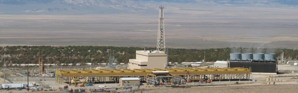
This is my second time getting a tour of the Blundell Geothermal Power Plant and I must say this time was much more informative then the last time. I think it was because last time I was with my geology group and we did not focus on the environmental aspect, actually we did not talk about the environmental aspect at all. The geology there is pretty easy so the tour was pretty simple, but this time it was a lot more interesting talking about the environmental impacts and we focused more on the methods of used at the plant to produce electricity. The power plant is run by pumping water that is about 400 degrees at very high pressure. The pressure is then released and then 18 of that water is turned into steam which is used to move a turbine that creates electricity. The remain 82% of the water is pumped back into the aquifer. There is a second phase that uses the remaining 18% of the water to raise the temperature of the isopentane high enough to change it from a liquid to a gas. This reaction again moves a turbine creating more energy. The good thing about geothermal is that it is about 98% efficient and does not waste anything and is available 24 hours a day.
There is problems though, one is that they use isopentane in their pipes. This is very flammable and toxic chemical and if spilled could have very bad environmental consequences. It has an EU classification of N which means that is dangerous for the environment. Another consequence is that since the pipes are over 400 degrees all year around in the winter the facility harbors many animals that use the heat to keep warm and to find food. This may not sound like a bad thing but because it is changing their natural habits it could be harming the specie.
Picture Citation:
"Blundell Geothermal Powerplant." State Geothermal Data. 2011.
http://www.stategeothermaldata.org/sites/stategeothermaldata.org/files/images/Utah_IMG_1031.jpg
Bryce Canyon
 Bryce Canyon is absolutely breath taking, there is not much more you can say to describe it you have to see it in person. The main attraction for the park is the canyon filled with "hoodoos." Walking through them you feel like you are in another world. They seem to defy physics and their red, orange and white colors are picturesque. Even though this park is absolutely beautiful we did not visit it for the the geological wonder that it is, we talked about the prairie dogs currently inhabiting part of the park.
In some records prairie dog populations at one time we said to number in billions. The inhabited the large majority of the mid-west and colonies have being recorded as large as 25,000 squaremiles. These numbers include all types of prairie dogs, the Utah Prairie Dog is the specific species we focused on. In 1920 their population was said to be about 95,000, but by 1972 only about 3,000 were estimated to exist. This is why in 1973 they were listed as an endangered species. Initial reports said they believed that the species would not make it to the year 2000, but now their population has grown to about 5,000 and the Bryce population is at about 130. New reports put a price tag of about 106 million dollars on making Utah Prairie Dogs no longer endangered (NPS.gov).

The interesting thing about Utah Prairie Dogs in that they have a symbiotic relationship with the bison in the area. High vegetation is not good for prairie dogs because it allows predators to sneak up on them. The bison keep the grass low in the prairies and the prairie dogs burrow in the soil over turning it and creating new nutrient rich grass.
Another thing we talked about in Bryce was the no surprises clause. It dealt with the reintroduction of the prairie dogs onto private property. It stated that if a private land owner allowed for the reintroduction of prairie dogs onto their property they would not be held to the standards of the Endangered Species Act. That way if they needed to build something on the land they were allowed to no questions asked. I think this is a good idea because otherwise private land owners would not allow for the prairie dog to be put on their land but the no questions asked policy should be a little more strict in my opinion.
Citations:
"Utah Prairie Dog." NPS - Bryce Canyon National Park. Web. 2011.
http://www.nps.gov/brca/naturescience/upd.htm
Picture Citations:
"Bryce Canyon." Anthony Sarnoski. 2011.
"Prairie Dog and Bison." Defenders of Wildlife. Web. 2011.
http://www.defendersblog.org/wp-content/uploads/2011/01/wm-SD-07-028.jpg
Great Salt Lake
 Great Salt Lake, oh man what an experience. First off it smells like the bay, all of the time and has man-easting gnats and mosquitoes. Aside from those to two things it is amazing, especially Antelope Island. It was absolutely beautiful the water was crystal clear, the hills of the island were very smooth and grassy it felt like we were in a different country, a lot different then the rest of the west I have seen. Swimming in the water felt like I was on a different planet. The moon and the stars were out and so bright you could almost touch them. Your body is so buoyant you feel weightless it is definitely an experience.
The Great Salt Lake is the way it because rivers (Bear, Jordan, and Weber Rivers) and stream flow through surround limestone collecting salts and then depositing them in the lake, since there is no outflow to the river the water evaporates and leaves behind the salt. This has been happening for about 45,000 years when Great Salt Lake was a part of the much larger Lake Bonneville, which created the Bonneville Salt Flats. This cycle has lead to a salinity peaking at about 28% which is remarkable because the ocean is only about 3%. Even though this is a natural processes it is starting to be researched wether humans are increasing the salinity because treated waste water which still can contain salts is pumped into the rivers which lead to Great Salt Lake.
Due to such high salinity no life form exist in the lake except brine shrimp and brine flies. This may sound like a barren waste land but the brine shrimp and flies attract millions of birds every year. Another advantage to the lake is that it is mined for magnesium, calcium, and sodium and the salt can be used in fertilizers or salt licks. The main problem is that since there is no life in the lake the lake bed is very still this allows pollutants to become trapped in the under it. If the lake bed is disturbed the pollutants will be put back into solution severely polluting the lake.
Picture Citations:
"Antelope Island." Anthony Sarnoski. 2011.
Bingham Canyon Mine

We tried to go to the Bingham Canyon Mine today but we were not able to get in. Apparently environmentalists are not as good at trespassing as geologists are. It is a shame that we could not see the mine ourselves because it sounds remarkable. It is 2.75 miles in diameter, 0.75 miles deep and has excavated 18.7 million tons of copper. At the current rate of $4.24 per pound that converts to roughly 159 billion dollars, but then again the mine has been in operation since 1873. The ore deposit at the site is caused by a quartz monazite porphyry intruding into a sedimentary rock. Quartz monazite is just a term for an igneous intrusion containing quartz and an equal amount of plagioclase and feldspar and porphyry means that the crystals are large and held together by a very fine grained matrix. Hairline fractures in the porphyritic rock allow hydrothermal fluids with high concentration of metals to intrude the rock this forms copper porphyry. The ore that is is being mined contains between 0.4 to 1% copper.
Citations:
"Amzing Facts." Kennecott Utah Copper. Web. 2011.
http://www.kennecott.com/visitors-center/amazing-facts/
Picture Citations:
"Bingham Canyon Mine." Moldy Chum. 2007.
http://moldychum.typepad.com/moldy_chum/images/2007/10/31/bingham_canyon_copper_mine_1.jpg
Flaming Gorge Dam

This was our first view of a dam along the Colorado and for our first in depth discussion on the Colorado River. This when I began to realize how important and amazing this river really was. There are over 20 dams on the the Colorado River and even though they were built for water management not energy. They main way to get them approved was to have them produce electricity. The problem with the Colorado river is that it is the only source of water for the mid-west. The mid-west is not suppose to be habitable, it is pretty much a huge desert but with human ingenuity water has been pumped from the river to 7 states, Mexico and Native American Nations, except that the later two are sometime forgotten during drier years. The river is separated in two 3 sections, the upper basin, the lower basin and Mexico. The two basins are each suppose to receive 7.5 million acre feet of water each year and Mexico is suppose to receive 1.5 million acre feet and the Native Americans are suppose to receive between 0.2 and 0.9 million acre feet a year. The water is dammedup between the dams along the river and then allocated accordingly. The problem with these dams is the are extremely damaging to the rivers natural ecosystem.

The first problem is that dams create reservoirs behind them make sure that they have water when it is needed and to also create a strong hydraulic head to make the most amount of energy from the hydroelectric power station. This dam floods the surrounding land and builds up sediment in areas that are not natural. Since the flow of the reservoir is very slow the sediments are deposited far upstream and never make it to the dam and even less make it through the dam to replenish down stream sandbars. This is a huge concern in the Grand Canyon. We are preserving this place because of its beauty but it natural fish and plant life is being destroyed by the dams. That is why a new mandate is in affect that will have the Grand Canyon flooded every ten years which will hopefully help build up some sediments. The problem is that this won't work the sand bars are very fragile ecosystems and a flood every 10 years will not bring it back to it's natural state.
Picture Citations:
"Flaming Gorge Dam." Pierre Galin. 2008. Web.
http://www.flickr.com/photos/pierre_galin/2471991477/
"Colorado River in Arizona." Anthony Sarnoski. 2009.
Rocky Mountain National Park
Today we visited our first National Park, Rocky Mountain National Park. We did not meet with any share holders but gave us two very informative lectures about wildlife management and land usage in the park. He brought up a point that is often over looked, National Parks were not protected when our country was formed. The first national park, Yellowstone, was not formed until 1872 and Rocky Mountain National Park was not established until 1915. Most of the west was just as beautiful and scenic as the National Parks that we have now, especially in the Rocky Mountains this land was just too difficult to inhabit. In the valleys there was still ranching, we think about National Parks as being areas of untouched land, where we go to see true wilderness. This is not the case, up until 1965 ranching was still allowed. This is also true about the National Forests which surround the park, they are set up more for access then for preservation. It's weird to think that the government protects these forest just to ensure that there is enough lumber to supply our country.
Another problem with National Parks is that they are set up to be enjoyed by the people and visitors do not want to visit a park that has just had a wild fire that bu
rn down thousands of acres of forest. The problem is that those fires are natural and are needed to maintain a healthy forest. Since the beginning of the parks existence until the late 1980's all fires were suppressed. The park service believed this was the right thing to do and did not realize that they were causing the forest to become extremely unhealthy and because the fires are not killing off some trees the forests are becoming much more dense which is not natural and makes the trees much weaker. This goes with what we learned about in The Dying of the Trees. Now that the trees are much weaker they are affected by pests easier. That is why large stands of trees are being killed by the pine bark beetle, t
hey are also affected by pollution more, and less likely to survive a severe change in temperature or climate.

It is interesting listening to Patrick talk because you can stare out into this beautiful wilderness and wonder what can be better and then he will tell you that what we are looking at is unnatural and extremely unhealthy. The problem is that the picture in our head of a unhealthy forest is actually the real healthy forest. Due to our management the forest is turning into a monoculture of almost all ponderosa pines.
Another problem we have is with wildlife management. In the 1800's any animal that large we saw as a threat to us or our livestock so we destroy any thing that breathed. In the early 1900's there were no elk left in the area which would later become Rocky Mountain National Park. In 1914 49 were introduced. By 1990 those 49 reproduced to become 1600 and today there are over 3500 and have become a nuisance.
The topic of wildlife management always comes back to the Endangered Species Act. It was written to help protect species that we were destroying but the rules for managing the species is so strict that there is always a conflict of interest. For most cases any time an endangered species is found on a property nothing can be done to negatively impact the species. That means that the land cannot be touched even if construction has begun. This is a problem with species like the Canada Lynx. In the Rocky Mountains it is endangered. That mean
s that if it is found on your property you have to let it live there and cannot effect it. The problem is that the exact same species also lives in Canada and is plentiful and healthy, but those to populations never interact so it can still be listed as endangered.
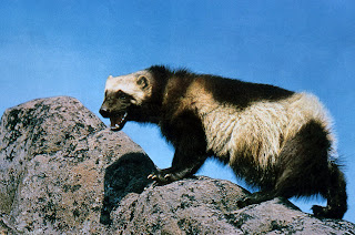
Another problem with the Endangered Species act involves the wolverine. The wolverine lives high in the snow cap tops of the Rocky Mountains. It is very illusive and does not come in contact with humans very often. A study in 2010 found that the population in the Rocky Mountains was only somewhere between 28 to 52 but it is not being protected (Schwartz). The official reason is that research was done on them but not enough specim
ens were found to get accurate results. What?! So there is not enough of them left research but they are not considered endangered. I also found it
staggering that one trapper admitted to legally killing 12 in the past couple years. Thats is nearly 25-50% of the remaining population destroy by one person, legally!
Citations:
Michael K. Schwartz, Copeland, J. P., Anderson, N. J. (2010). "Wolverine gene flow across a narrow climatic niche." Ecologoy 90. Page 3222-3232. Ecological Society of America.
Picture Citations:
"Rocky Mountain National Park." Anthony Sarnoski. 2011.
"Wolverine." 1965. National Park Service.
http://upload.wikimedia.org/wikipedia/commons/8/8c/Wolverine_on_rock.jpg
Tuesday, August 2, 2011
National Renewable Energy Lab + Western Resource Advocates

Today was our first day learning about the issues being dealt with out west. The first shareholder that we spoke to was a lady from the National Renewable Energy Lab in Denver. This was a great introduction into all of the different types of renewable energy being used. Especially for me since I am not an environmental major this was a really good introduction for the entire trip. Even thought I had a pretty good concept of what the lady was talking about, I still learned a lot. For example the sheer size of the wind turbines. I always knew they were very large but I never knew they were as big as a 747.
Another issue that I did not know about was that the Dakotas could potentially get 40% of their energy from wind but large oil companies like Peabody own large areas of
land out their and own the mineral rights incase their are resources that they want under ground so they do not want people to build on the land. That is why there are no wind turbines out west.
It was interesting to see inside their building was a small museum highlighting the different techniques and how they have changes over the years and it also showcased new technologies and the technologies that they invented. The one invention that I thought was really neat was the transpired solar wall on the side of the FedEx building. Since the technology worked very well and it seemed to be quite easy to install it seems like a really smart thing to start implementing more often.
The second part of the day we spent listen to a presentation
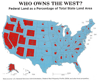
by a lady from the Western Resource Advocates. Since the lady from the first talked told us all we needed to know about renewable energy out west, it seemed like this lady told us all we needed to know about the Colorado River and land use. The statistic that I found the most interesting is when she started talking about how much of the west was owned by the government. She told us that 57% of Utah was federally owned as well as 85% of Nevada. To compare that to the east coast only 0.8% of New York is owned by the government and 0.4% of Connecticut. Since I grew up on the east coast it is hard to understand that a 85% of a state can be owned by the government.
She also talked about water use and water rights along the Colorado River. This was our first introduction to the Colorado River, which will turn into the main topic of our trip. One of the things that she talked about that was interesting was that the dams along Colorado River were not built for hydropower. That is a plus to having them but they are really made for water management. For example there is a coal power plant in Arizona that is not connected to the grid at all, its only purpose is to create energy to pump water from the Colorado River to be used in the Central Arizona Plan.
Picture Citations:
"Turbines Getting Larger." Sandia National Laboratories. Web.
http://i124.photobucket.com/albums/p7/NBBooks/WTGTurbinesGettingLargerSM.jpg
"Who Owns the West? U.S. General Service Administration. Web.
http://strangemaps.files.wordpress.com/2008/06/map-owns_the_west.jpg
Subscribe to:
Posts (Atom)